
#satellitedata


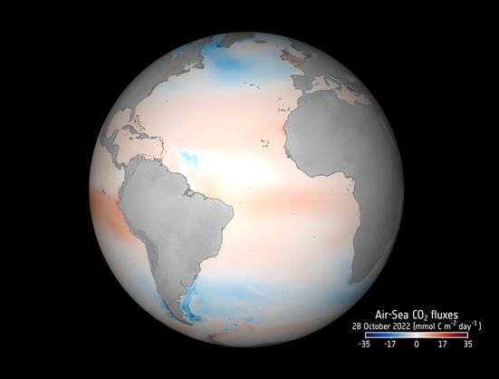
 Satellite product #OceanSODAETHZ gives unprecedented detail on how oceans absorb carbon. 8-day updates at 25km resolution!
 https://www.earth.com/news/satellites-reveal-how-oceans-absorb-carbon-in-unprecedented-detail/
US Defense Department will stop providing satellite weather data

https://www.europesays.com/2085368/ New Study Reveals Recent Ice Gains in Antarctica, But Long-Term Melting Continues #AntarcticaSeesRecentIceGainsButLongTermLossesReflectGlobalWarmingAntarctica #Climate #ClimateChange #ClimateStudy #EnvironmentalScience #GlobalWarming #IceSheet #NasaGrace #PolarIce #SatelliteData #TongjiUniversity
https://www.europesays.com/2068506/ Satellite Data Services Market Size to worth USD 55.17 Bn by 2032, Growing at 21.1% CAGR, Coherent Market Insights Cites Strong Government Support #business #CoherentMarketInsights #DataSegment #DataServices #MarketGrowth #MarketInsights #markets #SatelliteData #SatelliteTechnologies #ServicesMarket

Satellite Data is Revealing the Return of an Elusive Predator to Finland’s Remote Wilderness https://www.byteseu.com/964417/ #Finland #predator #SatelliteData #wolverine
https://www.europesays.com/1855950/ Luxembourg institute secures ESA funding for Digital Earth Twins development #3DModelling #agriculture #AI #ClimateChange #DigitalTwin #EarthObservation #environmental #EO #ESA #Lëtzebuerg #luxembourg #Luxemburg #Modelling #RemoteSensing #SatelliteData #SatelliteImagery #sustainability

 Thanks to Begum Demir @TUBerlin, end users - from search & rescue operators to climate scientists - can now search #SatelliteData archives with an image!
Read more @CORDIS_EU https://bit.ly/40Agkgs
#BigData #AI #EnvironmentalResearch #EarthObservations @Copernicus_eu
---
https://nitter.privacydev.net/ERC_Research/status/1883122737809702980#m

The Register: NASA’s Solar Dynamics Observatory datacenter flooded, offline until 2025. “Servers that store data collected by two NASA solar observation satellites are down – and the space agency doesn’t know when they’ll resume operations – after a four-inch chilled water pipe burst at the facility that houses them.”

How's it going everyone? If you have 10 minutes to spare this weekend, my co-founder Julia Wagemann and I would be super-grateful if you could share your experiences in keeping up with #geospatial data & tech via a short survey: https://forms.gle/fgRy46P233Xb9wAL7
We're taking part in an early stage startup program and are conducting this survey in order to develop a solution and also to use in our final pitch.
Thanks so much! #eochat #gischat #earthobservation #remotesensing #SatelliteData
Are your supply chains ready for the EUDR challenge? 
In today's episode of the Sustainable Supply Chain podcast, I chat with John Atkinson from LiveEO about leveraging accurate data to stay ahead.
Check out the full episode here: https://www.sustainablesupplychainpodcast.com/354320/episodes/15746459-eudr-compliance-simplified-the-role-of-accurate-data-in-risk-reduction

Our conference has been backed by Copernicus Data Space Ecosystem (CDSE): an initiative of the European Space Agency and the European Commission that is revolutionizing the processing and distribution of Copernicus Earth Observation (EO) data.
The project is being implemented by industrial consortium partners: T-Systems, CloudFerro, Sinergise, VITO, DLR, ACRI-ST, and RHEA.
#StateoftheMapEurope
#OSM
#OpenStreetMap #CDSE #Copernicus #EarthObservation #SatelliteData #CopernicusEU #EUspace #EOdata

does anybody know a quick and fairly robust way to detect pools from satellite/aerial images? a tutorial and/or python package would be splendid. asking for my students. thank you :)
/cc @bndktgrs

Advancements in AI Weather Forecasting - Microsoft Enhances Cloud and Precipitation Prediction Models: https://www.reviewspace.info/advancements-in-ai-weather-forecasting-microsoft-enhances-cloud-and-precipitation-prediction-models
Occasionally, and only partly to wind up my remote sensing colleagues, I describe #satelliteData as "basically a model". Per definition satellite data is electromagnetic radiation (at different frequencies/wavelengths) that has passed through (some of) the earth's atmosphere and then run through a model to give us "satellite data".
Not an original point but it does explain some interesting findings in @micefearboggis' latest on #MarineHeatwaves

Super excited to share that our latest research on boosting #CropClassification with #SatelliteData is finally out in #RemoteSensingOfEnvironment 
Look into our findings on improving accuracy in agricultural monitoring - you don't want to miss it if you're into #Agriculture and #RemoteSensing!  https://www.sciencedirect.com/science/article/pii/S0034425724001214
Also, a huge shoutout to the incredible team behind this: Valentin Barriere, Martin Claverie, Guido Lemoine and Raphaël d'Andrimont; well done! 

date: 2022-12-28 22:16:49
by: PhdScanner
 #Phdposition alert
 Under a month to apply for fully funded #phd focusing on enhancing #biodiversity employing #machinelearning #AI #satellitedata in #environmentalscience
 Deadline : 15th Jan 2023
Details
https://eo-cdt.org/step-by-step-application-process/
#agritech https://twitter.com/PhdScanner/status/1608225483660869634/photo/1

 : https://twitter.com/twitter/statuses/1608225483660869634
#PhdPosition