Continued thread


Part 3 of 3
#BikeTooter #VT #NH

Part 3 of 3
#BikeTooter #VT #NH
Scenes along the bike route, with details in the ALTs.
Part 1
#BikeTooter #VT #NH
Stats:
Day 1: 46 miles, 2,128ft elevation gain
Day 2: 50 miles, 3,400ft (plus 3 miles to groceries)
Day 3: 48 miles, 1,580ft
Even with all of the obsessive route planning ahead of time I didn't consider road construction or closures, and the first day had both with a big dirt road climb and some sketchy Class VI back country walking/biking to get past a road closure to the camping area.
I went on my first bike packing trip this week. Three days of following the Connecticut river from Hanover NH/Norwich VT to nearly the top of the Vermont/New Hampshire border. Two great days of weather and one rainy one. Beautiful country.
@easwatch #VTwx #EAS #WEA for Caledonia, #VT: National Weather Service: A FLASH #FLOOD WARNING is in effect for this area until 7:45 PM EDT. This is a dangerous and life-threatening situation. Do not attempt to travel unless you are fleeing an area subject to flooding or under an evacuation order. Source: NWS Burlington VT ** DO NOT RELY ON THIS FEED FOR LIFE SAFETY, SEEK OUT OFFICIAL SOURCES ***
#EAS #WEA for Caledonia, #VT: National Weather Service: A FLASH #FLOOD WARNING is in effect for this area until 7:45 PM EDT. This is a dangerous and life-threatening situation. Do not attempt to travel unless you are fleeing an area subject to flooding or under an evacuation order. Source: NWS Burlington VT ** DO NOT RELY ON THIS FEED FOR LIFE SAFETY, SEEK OUT OFFICIAL SOURCES ***
This was discovered while reading about Hall's Stream or Rivière Hall, which is a 25.2 mile river that forms much of the New Hampshire and Canadian border, with all of the undulations and squiggles one might imagine (zoom in!). After all of that important work being a border it unceremoniously enters Vermont as a plain old river only to dump into the Connecticut river.
Which brings us to the shape of upper Vermont. They could have stopped at Hall’s river and edge of Canada, but instead continued along the west side of the Connecticut until that crossed the latitude of lower Canada/upper Vermont.
Making a route in Ride with GPS and noticed it passes Terrible Mountain in Vermont, elevation 2,882ft. Wikipedia says this is probably what settlers named it due to terrain. There is the remains of a crashed airplane on top from 1968.
#BikeTooter #aviation #VT
Kid and I drove to the north country of Vermont to ride some Lamoille rail trail with a work buddy and his son. Since they live near it we managed a car drop so the kids (ahem) got a mostly flat/downhill 26 mile ride. ';^)
https://railtrails.vermont.gov/trails/lamoille-valley-rail-trail/
Checking out Vermont Lamoille Valley Rail Trail route with street view and found the guy who’s biking and recording it, along with a unicyclist. They currently don't hide the "invisible selfie-stick" from shadows.
#BikeTooter #RailTrail #VT
Guess where we went today?
#VT
Today I biked Vermont.
#BikeTooter #VT
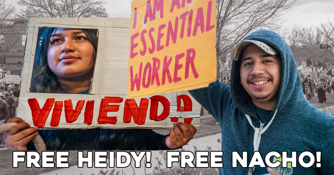
Action alert. Boosts appreciated 
So #ICE chose today, #NoKings day, with all eyes on the #fascism, to violently arrest longtime #Vermont migrant community organizer Nacho De La Cruz and his just graduated from high school step daughter after a bullshit traffic stop.
His organization, Migrant Justice, is circulating a petition. Please sign if you can.
https://actionnetwork.org/letters/free-nacho-free-heidy-not-one-more-deportation
..and if you’re in #VT sign up for Migrant Justice alerts and show up to defend our neighbors!
From a flash-mob in Bennington to a state-long relay up Route 7, Vermonters in more than thirty cities and towns turned out on Saturday as part of "No Kings Day" — a nationwide protest of the Trump administration.
https://www.vermontpublic.org/local-news/2025-06-14/thousands-in-vermont-turn-out-to-protest-trump-policies #Vermont #VT

#BostonWeekend 23/x
Sat - 50501 No Kings events, pretty much all over.
#MA/#BOS has it rolled into Pride https://www.mass50501.org/events/june14
National: https://www.fiftyfifty.one/events
Stellar roundup for #Maine by @DoomsdaysCW here: https://kolektiva.social/@DoomsdaysCW/114671005923091648
#NationalDayOfDefiance #NoKings #June14 #FiftyFiftyOne #Boston #massachusetts #Vermont #NewEngland #NH #newhampshire #VT #RhodeIsland #RI #CT #Connecticut

Executing this fix has been put on a red cue because the machine in question died a terrible early death
#freeBSD #ghostBSD #man #VT #console #Font #size #OpenSource #POSIX
https://forums.freebsd.org/threads/how-to-change-vt-console-font-size.91145/#post-630220
One of these days, I'll get around to formally pointing out that the Euro symbol really is actually engraved at E04 on (according to Currys) most U.K. keyboards, like you used to have it in the U.K. keyboard layout back in 2014.
Yes, a few keyboards have it engraved at D03. Microsoft's U.K. (normal+extended) layout for Windows makes it Level 3 shift + E04, however, as engraved on the majority.
https://currys.co.uk/techtalk/how-to/how-to-find-the-euro-symbol-on-your-pc-or-laptop-keyboard.html
More photos from yesterday. Sunday I started putting “bags" on the bike, to see what kind of rig I could make for bike packing. Surprised the little frame bag I sewed was just the right size for tent poles and stakes. Panniers from 80’s aren't waterproof, but held tent/fly which don't need that? Sleeping system in wp case on rack. Front bag for food and clothes, top frame bag snacks. It was pretty heavy, especially going up hills, but also nicely balanced.
#BikeTooter #bikepacking #VT #NH #history
“We interrupt the regularly scheduled program of daily horrors” … YES, PLEASE! 
80s kids is ON TOUR NOW!  ️
️
Coming to these fine cities:
MAY 10 #Burlington #VT
MAY 15 #Minneapolis MN
MAY 16 #StLouis MO
May 20 #KansasCity MO
MAY 22 #DesMoines IA
MAY 23 #Omaha NE
MAY 27 #Denver CO
MAY 30 #Boise ID
MAY 31 #BakerCity OR
JUN 06 #Spokane WA
JUN 12 #Seattle WA
JUN 19 #Oakland CA